Sunday, November 11, 2007
Cappadocia , Kapadokya
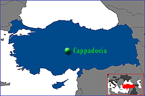
Kapadokya
The name of the ancient province in central Anatolia. The irresistible region is created through violent eruptions of the volcanoes Mt. Erciyes (3,916 m.) and Mt. Hasan (3,268 m.) three million years ago. Places which are visited most in the region are : The Göreme Open -air museum with its carved churches, the Ihlara Valley, the underground cities of Kaymaklı or Derinkuyu, the fairy chimneys, Avanos with its handicrafts, Zelve and Ürgüp.
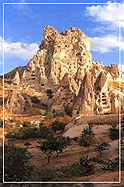
The Taurus mountains, which are technically part of the Alpine chain, in their creation 60 million years ago, caused the warping of the Anatolian plateau. The resulting volcanoes, including the spectacular Mount Erciyas and Mount Hasan, produced the tuff from which the unique landscape of Cappadocia is formed.
There is no historical record of activity from these ancient volcanoes (and they certainly won’t interrupt your holiday) but there are three surviving memorials, although it is likely that these were created by people who had heard about the eruptions through folk history rather than having actually witnessed it themselves. One of the wall paintings in Çatalhöyük (which is incidentally one of the oldest paintings known to archaeology) shows an eruption as does an ancient engraved coin from Caesarea (Modern Kayseri). The remains of a Persian temple dedicated to fire near Mount Erciyas show that this volcano was once regarded as sacred.
It took millions of years for the ash from these volcanoes to form a layer of tuff, covered in places by a further layer of basalt lava. The basalt ultimately cracked and split under attack from the weather and rainwater seeped down through the cracks and splits to slowly erode the tuff itself. The natural effects of alternating very hot and very cold weather and the rain and the wind breaking down the rock’s resistance caused (and continues to cause) the emergence of the tall cones of tuff capped by hard basalt which the Turks call Fairy Chimneys.
Where there is no basalt layer to protect the tuff lovely valleys have been formed connected to the plateau by steep canyons of andesite and basalt. The canyons of Soğanlı and Ihlara are particularly stunning examples, Ihlara canyon being 650 feet in depth in some parts.
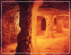
The valleys are sheltered and fertile with an almost temperate climate. The tuff is easily worked and, for milennia, has provided dwellings and and storerooms, both above and below ground, for smallholders. Despite it’s increasing popularity with visitors, Cappadocia is very much home to small farmers who can still be seen every day tending their orchards, vineyards and field crops and riding their donkeys home to their cave houses.
Source:
‘A Complete Guide to Cappadocia’ ISBN 975 7672 106 Published by the Cappadocia Tourism Promotion Foundation Nevşehir Turkey.
Hierapolis , Pamukkale
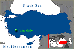
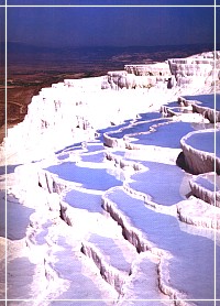
Hierapolis , Pamukkale
Until forty or fifty years ago, Pamukkale was a place where travelers who happened to pass by found peace and tranquillity and the opportunity for quiet meditation by the side of the sacred spring that still lies exposed, amid the few ancient columns and in the deep silence of the tombs that lay scattered over the countryside to the west and extended out towards the surrounding hills. In spite of the doubtful merits of present-day developments, and in spite of all the ugly building construction that has taken place, the seething crowds, the noise and pollution, one can still confidently assert that Pamukkale has lost nothing of its former attractions.
Pamukkale is located in the Inner Aegean region at a distance of 20 km from the town of Denizli. This lovely, rapidly developing district in the Menderes valley, which enjoys a temperate climate over the greater part of the year, has all the conditions required for an ideal touristic resort.The tectonic movements that took place in the fault depression of the Menderes river basin gave rise to the emergence of a number of very hot springs, and it is the water from one of these springs, with its large mineral content, chalk in particular, that has created the natural wonder now known as Pamukkale, Cotton Fortress or Baumwollenschloss, a very appropriate name for such a phenomenon…
You may approach Pamukkale by the main roads marked on your map, but there are also other ways, according to the direction from which you are coming. For example, if you approach from the West you can branch off to the left at the sign shortly after Sarayköyü.This will give you the opportunity of seeing and getting to know quite a few very interesting Western Anatolian villages.On approaching Pamukkale, whether you choose the route through these villages or arrive by the Denizli road you will be confronted by one of the most remarkable landscapes to be seen anywhere in Turkey.The first thing you will see is a rock platform over 100 m in height rising up from the plain. The slopes of this hill, which look from a distance like a great white speck, are covered with large numbers of pools and terraces.As you come nearer, you will begin to see this natural phenomenon, which resembles a frozen waterfall, in greater detail.
From the edge of every terrace and every step in this fascinating natural phenomenon that has gradually formed throughout the ages hang brilliantly white stalactites, and you can hear the joyful splashing of the waters of the hot springs as they cascade down over slopes where their flow is impeded only by clumps of oleanders.The temperature of the water forming the travertines, which issues from the hot springs on the hills above, falls to around 33 C° lower down.On emerging to the surface, the solution of calcium-carbonate in the spring water decomposes into carbon dioxide, calcium carbonate and water. The carbon dioxide is released into the air while the calcium carbonate separates off from the water to form a grayish-white limestone sediment.The beds of the water-courses are filled up with these limestone deposits and the water, confronted with these obstacles, splits up into several branches.The water flows over the slopes into pools, the small basins surrounding them and finally into the fields below.It is in this way that these terraces over 100 m in height composed of layers of the accumulated limestone sediment have been gradually formed in the course of the ages. As the limestone sediment reaches a certain level the water accumulates in pools and, as these pools fill up, overflows into smaller pools in the vicinity and from these flowsinto the small hollows and depressions around them.The limestone layers in the pools rise up in steps, one above the other, and the continual flow of water keeps this process in operation.The stalactites form one of the most important features in the landscape.
With the formation of the layers and the emergence of steps and terraces one above the other, the water leaves the limestone deposit behind it and drips down in the form of stalactites, as in the Damlataş caverns.The calcium oxide in the water adds to the thickness of the white layers and widens the terraces, producing pools in fantastic shapes reminiscent of oyster shells or flower petals, while the small amount of sulphur and iron oxide produces stripes of yellow, red and green over the white of the limestone. Any object left in the water at Pamukkale will take on a coating of limestone within a very few days. Now, as in the olden days, the water flows through open channels, and in cold weather you can see columns of mist dancing over the surface.Although the water flowing from the hot springs on the southern slopes of Çaldağ rapidly loses heat during its flow through these open channels it is still hot enough to make it possible for one to bathe throughout six months of the year in the open-air swimming pools in the motels and on the terraces.
Hierapolis , Pamukkale
Hierapolis , Pamukkale
Until forty or fifty years ago, Pamukkale was a place where travelers who happened to pass by found peace and tranquillity and the opportunity for quiet meditation by the side of the sacred spring that still lies exposed, amid the few ancient columns and in the deep silence of the tombs that lay scattered over the countryside to the west and extended out towards the surrounding hills. In spite of the doubtful merits of present-day developments, and in spite of all the ugly building construction that has taken place, the seething crowds, the noise and pollution, one can still confidently assert that Pamukkale has lost nothing of its former attractions.
Pamukkale is located in the Inner Aegean region at a distance of 20 km from the town of Denizli. This lovely, rapidly developing district in the Menderes valley, which enjoys a temperate climate over the greater part of the year, has all the conditions required for an ideal touristic resort.The tectonic movements that took place in the fault depression of the Menderes river basin gave rise to the emergence of a number of very hot springs, and it is the water from one of these springs, with its large mineral content, chalk in particular, that has created the natural wonder now known as Pamukkale, Cotton Fortress or Baumwollenschloss, a very appropriate name for such a phenomenon…
You may approach Pamukkale by the main roads marked on your map, but there are also other ways, according to the direction from which you are coming. For example, if you approach from the West you can branch off to the left at the sign shortly after Sarayköyü.This will give you the opportunity of seeing and getting to know quite a few very interesting Western Anatolian villages.On approaching Pamukkale, whether you choose the route through these villages or arrive by the Denizli road you will be confronted by one of the most remarkable landscapes to be seen anywhere in Turkey.The first thing you will see is a rock platform over 100 m in height rising up from the plain. The slopes of this hill, which look from a distance like a great white speck, are covered with large numbers of pools and terraces.As you come nearer, you will begin to see this natural phenomenon, which resembles a frozen waterfall, in greater detail.
From the edge of every terrace and every step in this fascinating natural phenomenon that has gradually formed throughout the ages hang brilliantly white stalactites, and you can hear the joyful splashing of the waters of the hot springs as they cascade down over slopes where their flow is impeded only by clumps of oleanders.The temperature of the water forming the travertines, which issues from the hot springs on the hills above, falls to around 33 C° lower down.On emerging to the surface, the solution of calcium-carbonate in the spring water decomposes into carbon dioxide, calcium carbonate and water. The carbon dioxide is released into the air while the calcium carbonate separates off from the water to form a grayish-white limestone sediment.The beds of the water-courses are filled up with these limestone deposits and the water, confronted with these obstacles, splits up into several branches.The water flows over the slopes into pools, the small basins surrounding them and finally into the fields below.It is in this way that these terraces over 100 m in height composed of layers of the accumulated limestone sediment have been gradually formed in the course of the ages. As the limestone sediment reaches a certain level the water accumulates in pools and, as these pools fill up, overflows into smaller pools in the vicinity and from these flowsinto the small hollows and depressions around them.The limestone layers in the pools rise up in steps, one above the other, and the continual flow of water keeps this process in operation.The stalactites form one of the most important features in the landscape.
With the formation of the layers and the emergence of steps and terraces one above the other, the water leaves the limestone deposit behind it and drips down in the form of stalactites, as in the Damlataş caverns.The calcium oxide in the water adds to the thickness of the white layers and widens the terraces, producing pools in fantastic shapes reminiscent of oyster shells or flower petals, while the small amount of sulphur and iron oxide produces stripes of yellow, red and green over the white of the limestone. Any object left in the water at Pamukkale will take on a coating of limestone within a very few days. Now, as in the olden days, the water flows through open channels, and in cold weather you can see columns of mist dancing over the surface.Although the water flowing from the hot springs on the southern slopes of Çaldağ rapidly loses heat during its flow through these open channels it is still hot enough to make it possible for one to bathe throughout six months of the year in the open-air swimming pools in the motels and on the terraces.
Olympos , Çıralı Yanartaş , Cirali Yanartas
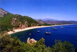
Dated 3rd century B.C.,Olympos was founded on both of sides of the mouth of a river. A member of the Lycian federation,the city was invaded by the Cilician pirates until 78 B.C. and then became a part of the Roman empire.The most interesting building here today is the remains of the door of a temple located west of the river.In Chimera near Olympos,a flame comes out of the ground constantly.As displayed in the Anatolian Civilizations Museum in Ankara,Hephaistos is a fire breadhing,goat headed lion with a snake head at the tip of his tail and with eagle wings.This figure was inspired from the Hitttes.The people of Olympos build a temple by the perpetual flame for their most important god,Hephaistos(Vulcain in Roman mythology).
Subscribe to:
Posts (Atom)